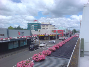
Hastings, New Zealand
| Hastings Heretaunga (Maori) |
|
|---|---|
 |
|
 Hastings
|
|
| Coordinates: | |
| Country | |
| Region | Hawke's Bay |
| Territorial authority | Hastings District |
| Government | |
| - Mayor | Lawrence Yule |
| Area | |
| - Territorial | 5,229 km2 (2,018.9 sq mi) |
| Population (June 2010 estimate)[1] | |
| - Territorial | 75,100 |
| - Density | 14.4/km2 (37.2/sq mi) |
| - Urban | 65,700 |
| Postcode(s) | 4120, 4122 |
| Website | http://www.hastingsdc.govt.nz/ |
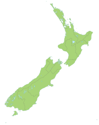
The city of Hastings is a major urban settlement in the Hawke's Bay Region of the North Island of New Zealand, and it is the largest settlement by population in Hawke's Bay. Hastings city is the administrative centre of the Hastings District. Hastings is located some 20 km inland from the neighbouring port city of Napier.
Less than twenty kilometres separate the centres of Hastings and Napier, and as such the two are often grouped together as "The Twin Cities" or "The Bay Cities", and are increasingly treated together in official statistics. Their combined population is 124,400, making the combined urban area the fifth-largest by population in New Zealand, between Hamilton (203,400) and Tauranga (120,000).
During the 1989 local government reforms Hastings City was amalgamated with Havelock North Borough and the Hawkes Bay County to form the modern Hastings District. The County Council offices in Napier were closed down and the new Hastings District Council offices were located in Hastings on two sites. Fortunately for the previously land-locked Napier, Napier City boundary was expanded to include Bay View and Meeanee. The Hastings District now entirely surrounds Napier City, and encompasses a much larger area than Napier. However, unlike the predominantly built-up Napier, much of the Hastings District is rural and sparsely populated, and the two local authorities service a similar population; the Hastings District has approximately 75,100 (June 2010 estimate).[1] residents. Because of their close proximity to each other and their relatively small populations, Napier and Hastings are often seen as an obvious candidate for further amalgamation.
The principal settlements in the Hastings District are the city of Hastings itself and the nearby towns of Flaxmere and Havelock North. These main centres are surrounded by thirty-eight rural settlements, including Clive, Haumoana and Bridge Pā. Hastings District covers an area of 5,229 square kilometres (2,018 square miles) and has 1.7 % of the population of New Zealand, ranking it fourteenth in size out of the seventy-four territorial authorities.
Since the merger of the surrounding and satellite settlements, Hastings has grown to become the largest urban area in Hawke's Bay. Now the region's main centre of commerce, industry and trade, as shown by the ever-expanding skyline of multi-storey office buildings in its centre, Hastings has grown rapidly with the help of the smart and tidy gridiron city planning system, crisscrossed by the railway line running northeast-southwest and the main southeast-northwest artery, Heretaunga Street, which also links the city with its suburban centres of Havelock North and Flaxmere.
Many Hastings residents work in the city, and the area is populated by middle-to-upper income families in some suburbs and areas, and then middle-to-lower income families in other areas, especially towards Camberley and Flaxmere.
Contents |
History
The Māori owners leased approximately seventy square kilometres on the Heretaunga Plains to Thomas Tanner in 1867; Tanner had been trying to purchase the land since 1864. In 1870, twelve people, known as the "12 apostles", formed a syndicate to purchase the land for around £1 10s an acre (£371 per km²).
Many local people firmly believe that Hastings was originally named Hicksville, after Francis Hicks, who bought a 100-acre (0.40 km2) block of land, which now contains the centre of Hastings, from Thomas Tanner. However, this story is apocryphal. The original name of the location which was to become the town centre was Karamu. In 1871, the New Zealand Government decided to route the new railway south of Napier through a notional Karamu junction in the centre of the Heretaunga Plains. This location was on Francis Hicks's land. The decision on the railway route was based largely on two reports by Charles Weber, the provincial engineer and surveyor in charge of the railway. Karamu junction was re-named Hastings in 1873. (On 7 June 1873, the Hawke's Bay Herald reported: "The name of the new town is to be Hastings. We hear it now for the first time.") Exactly who chose the name has been disputed, although Thomas Tanner claimed that it was him (see Hawke's Bay Herald report 1 February 1884) and that the choice was inspired by his reading the trial of Warren Hastings. In any event, the name fitted well with other place names in the district (Napier, Havelock and Clive), which were also named after prominent figures in the history of British India. {Boyd, M.B. (1984) City of the Plains - A History of Hastings, Victoria University Press for the Hastings City Council, pp.16-21}
The first train took the twelve-mile (19 km) trip from Napier to Hastings in 1874.
A big jump in the local economy occurred when Edward Newbigin opened a brewery in 1881. By the next year, there were 195 freeholders of land in the town.
Vineyards and fruit growing were the first industries for Hastings. With around six hundred people, the town was incorporated as a borough on 20 October 1886.
In 1918, nearly 300 people died of a flu epidemic that swept Hawke's Bay.
Electricity came to Hastings in 1919.
Ninety-three people were killed in Hastings by the Hawke's Bay earthquake of 3 February 1931, which destroyed or damaged almost every building in the town.
During World War II, Allied troops were billeted at the Army, Navy and Air Force (ANA) Club, and in private homes. One hundred and fifty members belonging to sixteen different local clubs packed supplies to be sent to allied soldiers.
In 1954, Hastings was the first city in New Zealand to introduce fluoridation of its water supply.[1] The intention was to compare the effect on tooth decay with that in the unfluoridated city of Napier over a ten year period. The study was criticised for its methodology and results, and remains controversial. [2]
The city was hit by an earthquake measuring 5.9 on the richter scale at 11.25pm on August 25, 2008. The earthquake caused minor damage to shops, where stock was shaken off shelves. Minor power outages were also reported.
Commerce
Hastings District, as one of the largest apple, pear and stone fruit producing areas in New Zealand has an important relationship with the Napier Port. It has also become an important grape growing and wine production area with the fruit passing from the growers around Metropolitan Hastings and then to Napier for exporting. Napier is an important service centre for the agriculture and pastoral output of the predominantly rural Hastings District.
Commercial business is heavily weighted by large format retail in Hastings City, whereas in contrast, Havelock North, Taradale and central Napier retail areas have a more boutique flavour.
Geography
Situated on the fertile alluvial Heretaunga Plains, Hastings District features varied natural landmarks from the Havelock Hills to the sandy beaches. The local area is very productive, with orchards, farms and vineyards. Commonly referred to as the 'Fruit Bowl of New Zealand', the main industries are largely agricultural, with food processing plants and canneries being major local employers. Honey is also a well-known local product. A common New Zealand brand, 'Wattie's' (part of the Heinz-Watties group), is known for its Wattie's Tomato Sauce'.
Hastings District features the only sandy beaches in the Hastings-Napier area, notably Ocean Beach, Waimarama, and Waipatiki.
Hastings has a Mediterranean climate, with over 2200 sunshine hours annually and an average rainfall of less than 800 mm (31.5 in). It is one of the country's warmest annually and the hottest place in summer with New Zealand's highest January maximum average of 26 °C (79 °F): Alexandra has 23.5°C (74°F) and Christchurch 22.5°C (73°F). Because of its location 15 km (9 miles) inland, the sea breeze does not tend to have the same effect on Hastings' climate as it does on Napier. It is not uncommon for the temperature to be over 30°C (86°F) on summer days. Hastings received an official weather station only in 2003, so high temperature readings prior to that are disputed. Some unofficial estimates show that it may have reached the national record of 42.4°C (108.3°F) during the 1973 heatwave. In winter, maximum highs of 17°C (59°F) are frequent, and occasionally the temperature will exceed 20°C (68°F) with northwest winds. Hastings' Mediterranean climate brings dry weather which means humidity is low for farmers but often causes droughts in summer. Thunderstorms are occasional in Hastings, but usually bring heavy rain and hail, sometimes large, which is damaging to nearby orchards.
| Climate data for Hastings, New Zealand | |||||||||||||
|---|---|---|---|---|---|---|---|---|---|---|---|---|---|
| Month | Jan | Feb | Mar | Apr | May | Jun | Jul | Aug | Sep | Oct | Nov | Dec | Year |
| Source: NIWA Climate Data[2] | |||||||||||||
Demographics
Hastings District encompasses a larger area of population compared with Napier. The Urban Area of Hastings in 64,700 which includes the surrounding Heretaunga Plains from Clive to Bridge Pa. The central urban area however which is specifically the population centre of Hastings, Flaxmere, and Havelock North is around 58,758 (at the 2006 census). Due to restrictions on encroachment of land, satellite suburbs have absorbed the residential expansion of the city.
At the 2006 census, Hastings District had a population of 70,842, an increase of 3,414 people, or 5.1 percent, since the 2001 census. There were 25,557 occupied dwellings, 1,920 unoccupied dwellings, and 273 dwellings under construction.[3]
Hastings's ethnicity was made up of (national figure in brackets): 67.0 percent European (67.6 percent), 23.8 percent Maori (14.7 percent), 2.85 percent Asian (9.2 percent), 5.1 percent Pacific Islanders (6.9 percent), 0.5 percent Middle Eastern/Latin American/African (0.9 percent), and 12.1 percent 'New Zealanders'.[3]
Hastings had an unemployment rate of 4.6 percent of people 15 years and over, compared to 5.1 percent nationally. The average annual income of all people 15 years and over in Napier was $22,600, compared to $24,400 nationally. Of those, 45.5 percent earned under $20,000 annually, compared to 43.2 percent nationally, while 14.4 percent earned over $50,000 annually, compared to 18.0 percent nationally.[3]
Tourism
Hastings District is quite historic and is very welcoming of tourists, and features beautiful coastal beaches, notably Ocean Beach and Waimarama Beach. Hastings also is the home of Hawke's Bay's largest amusement park, a water park called 'Splash Planet', which replaced 'Fantasyland' near the turn of the millennium. This is a massive attraction in Hastings City and draws many people.
Hastings suffered similar to Napier in the 1931 Hawke's Bay earthquake. However, because of the lesser damage by fire and more intact buildings, Hastings was able to regenerate faster, with many new businesses started here rather than in Napier. Both towns gained a legacy from the disaster by rebuilding in the then-fashionable and highly distinctive Art Deco style, similar to that of Miami, FL, USA. Sadly, as commerce has improved in Hastings of late, resulting in the skyrocketing of land prices.
Scheduled airline services to Hawkes Bay operate through Hawkes Bay Airport, though Hastings Aerodrome for private planes is nearby.
Redevelopment
By the end of the twentieth century, Hastings was declining, suffering economic downturn with industries and businesses closing or moving elsewhere. However, after multi-million dollar regeneration projects and the employment of artists, Hastings has seen a change in its aesthetics. The rapidly-growing Havelock North, has seen businesses returning, and once abandoned shops of Hastings City being replaced with new bars, cafés, restaurants and shops. Along with the regeneration of the retail district, heightened commercial activity has led to the building of multi-storey office blocks in the centre, marking Hastings one of New Zealand's major commercial centres. With its renewed confidence, Hastings District Council has been exploiting the boom, promoting tourism around its thriving and accessible shopping district, and commissioning new works of art, sculptures and public buildings, including the new Hawke's Bay opera house.
A controversial idea by the Hastings District Council is to relocate the Nelson Park sports ground to a new facility on the edge of the Hastings urban area to make way for a large megacenter, akin to large cookie-cutter American stores. The large-format retail zone will house larger stores such as The Warehouse and speciality stores (like Spotlight, Dick Smith Electronics, and Noel Leeming). The new sports park is proposed as a regional sports park and includes a velodrome, all weather athletics track and sports grounds for most other sporting codes represented in NZ sport.
Horse of the Year show
Hawkes Bay A&P Showgrounds in Hastings is the home to the annual NZ Horse of the year show, held in March. It is one of the biggest sporting events in the southern hemisphere, and attracts 2500 horse and rider combinations competing in 19 disciplines including Dressage, Showhunter, Eventing, Showjumping and polocrosse and many breed classes to name a few. It has a budget of around $NZD3million, and attracts over 70,000 visitors from over NZ and internationally over the 5-day show.
Sister cities
The Hastings relationship with the Chinese city Guilin started in 1977, after a research scientist, Dr Stuart Falconer identified a number of common areas of interest between the two cities, including horticulture and their rural-urban mix.
|
Notable Former/Current Residents of Metro Hastings
- Josh Kronfeld - Rugby Player and former All Black.
- John Timu - Former All Black and Bulldogs representative in Rugby League. He attended Lindisfarne College in Hastings.
- Taine Randell - Rugby player and former All Black captain. He attended Lindisfarne College in Hastings.
- Paul Holmes (broadcaster) - Radio and television broadcaster (reportedly highest paid)
- Georgina Evers-Swindell - Olympic rower and gold medalist (Evers-Swindell Twin Duo)
- Caroline Evers-Swindell - Olympic rower and gold medalist (Evers-Swindell Twin Duo)
- Alan Duff - Author (Once Were Warriors)
- James Wattie - Industrialist/Entrepreneur and founder of Watties
- Eric Young (broadcaster) - Prime TV news presenter (lead anchor of evening news)
- Donna Awatere Huata - Prominent Maori Politician convicted of fraud
- Greg Murphy - V8 Supercar racer
- Joh Bjelke-Petersen - Prominent Australian Politician and former Queensland Premier
- Alfred Meebold - Botanist, writer, and anthroposopher
- Robert Felkin - Medical missionary, explorer and ceremonial magician
- Peter Lyons - New Zealand Gliding champion
- George Nepia - Former All Black Great(attended Maori Agricultural College)
- Sam Kelt - Local businessman and sponsor of the Kelt Capital Stakes (prizemoney of NZ$2,000,000)
- John Cowie - Developed and marketed the Jandal, after a trip to Japan. Died in Te Awanga.[4]
- Phil Judd - Musician, composer and founding member of Split Enz
- Mark Paston - footballer, New Zealand national football team goalkeeper.
- Joan Wiffen - Amateur paleontologist who discovered the first dinosaur fossils in New Zealand
- Ian Smith (New Zealand cricketer) - Former Central Districts and New Zealand cricketing great
Gallery
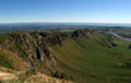
 St Aubyn St, looking towards Te Mata Peak |
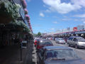
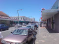 Market St, looking north |
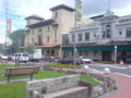
 Heretaunga St West |
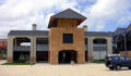
 The Hawkes Bay Opera House Complex |
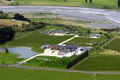
 Large format zone north of Hastings CBD |
 Te Mata Peak look towards Napier and Hawke Bay |
 Craggy Range Winery |
 Craggy Range Winery up close |
 Te Mata Estate |
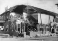 Damage to the post office in the 1931 Hawkes Bay Earthquake |
 Damage to the Herald Tribune in the 1931 Hawkes Bay Earthquake |
See also
- Heretaunga Street
- Karamu High School
- Havelock North
- Clive
- Bridge Pā
- Flaxmere
- Napier
- Taradale
- Ocean Beach
- Hawkes Bay Airport
Notes
- ↑ 1.0 1.1 "Subnational population estimates at 30 June 2010 (boundaries at 1 November 2010)". Statistics New Zealand. 26 October 2010. http://www.stats.govt.nz/~/media/Statistics/Methods%20and%20Services/Tables/Subnational%20population%20estimates/subnational-pop-estimate-jun2001-2010.ashx. Retrieved 26 October 2010.
- ↑ "CLINFO". NIWA. http://cliflo.niwa.co.nz/pls/niwp/wgenf.genform1_proc. Retrieved April 22, 2009.
- ↑ 3.0 3.1 3.2 Quickstats about Hastings District
- ↑ "How jandals got their handle". http://www.hbtoday.co.nz/localnews/storydisplay.cfm?storyID=3757791&thesection=localnews.
References
- Moss, Maryan. 1999. Historic Outline of the Hastings District.
- Boyd, Mary Beatrice. 1984. City of the Plains - A History of Hastings, Victoria Universtity Press for the Hastings City Council
External links
|
|||||||||||||||||||
|
||||||||||||||||||||||||||||||||